The HSASK automotive integrated navigation system uses PPP-RTK and IMU to achieve high-precision positioning. Since PPP-RTK integrates low-orbit satellites and ground reference stations to achieve positioning, it does not rely on the support of base stations and networks and can perform single-point positioning at any location and time. This makes PPPRTK independent and flexible and suitable for various environments. and application scenarios, including cities, rural areas, remote areas, etc. PPP-RTK has strong anti-interference ability and can reduce positioning errors through multi-path suppression and processing of surrounding environment interference. This allows PPP-RTK to still provide excellent performance in complex signal environments and harsh weather conditions around the world. Reliable centimeter-level positioning performance.
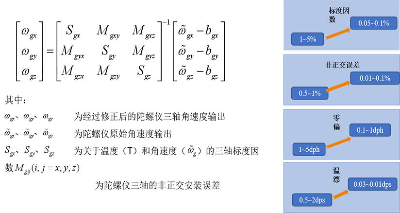
At the same time, considering that satellite positioning signals are easily lost or interfered with in scenes such as urban canyons, tunnels, and parking lots, high-precision MU is used to achieve accurate trajectory estimation. Our company uses unique IMU calibration technology to enable the IMU to show the best performance under working conditions, reduce the impact of non-orthogonal errors, reduce the impact of zero bias and temperature drift, and after correction, the track estimation performance can be improved by 10 times.
The high-precision integrated navigation and positioning system adopts the extended Kalman filter algorithm, adopts the vehicle motion constraint model, and uses the vehicle speed signal extracted from the CAN bus to achieve multi-source sensor signal fusion positioning, providing high-precision positioning covering the entire scene for intelligent driving, ensuring driving Safety.
- PPP-RTK high-precision algorithm
- Error State Kalman Filter, ESKF
- Unique IMU calibration algorithm
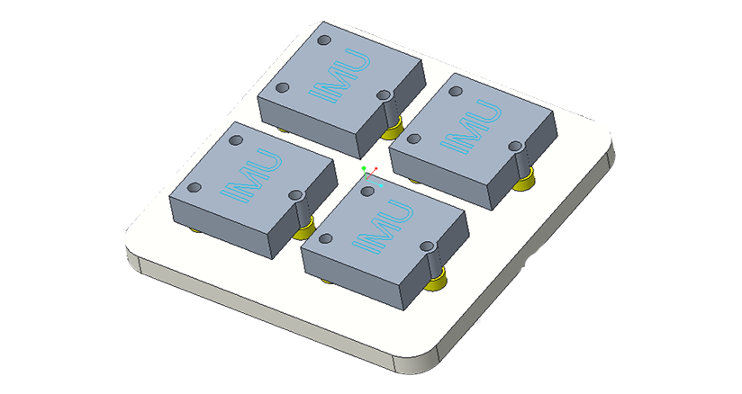
- IMU array improves accuracy and robustness
-
PPP-RTK high-precision algorithmCentimeter-level positioning accuracy, independent of base station and network support, providing second-level real-time positioning results, suitable for global positioning, strong anti-interference ability, etc.

-
Error State Kalman Filter, ESKFThe strapdown inertial navigation algorithm is used to recursively calculate the values output by the inertial device to obtain the navigation parameters such as attitude, speed and position of the moving vehicle at the current moment.
GNSS and SINS work independently, and finally the data of the two are fused through the Kalman filter algorithm to correct the relevant parameters of the SINS system, and finally provide better navigation estimation results.
-
Unique IMU calibration algorithmUtilize high-precision IMU to achieve accurate trajectory estimation. Our company uses unique IMU calibration technology to enable the IMU to show the best performance under working conditions, reduce the impact of non-orthogonal errors, reduce the impact of zero bias and temperature drift, and after correction, the track estimation performance can be improved by 10 times.

-
IMU array improves accuracy and robustnessIt provides higher-precision positioning and attitude measurement, has strong robustness and fault tolerance, and can be combined with other sensors (such as cameras, lidar, etc.) to achieve multi-modal perception and fusion.

-
High efficiency and ability
The futuristic car sound system can be used so that the sound system can be adjusted to suppress the noise.
By changing the internal and external environment of the car, the system can be adjusted automatically, the sound can be set up and the noise can be removed, and the system has been changed to provide a clearer and more customized sound system.
-
Space utilization and collection
As a result, the interior space of the car is limited, the comprehensive design of the new direction is improved, and the effective release of the Japanese vocal instrument model is achieved, thereby maximizing the use of space. In addition, when Shoko Howa's vocal instruments were assembled, the interior of the car was assembled, and the seats, car door, and flower board, etc., were provided, making it possible to use the space for a better musical performance.
-
Wireless connection intelligence control system
Futuristic car sound systems can use more wireless connection technology, such as wireless connection, Wi-Fi, etc., making it more convenient to use wireless connection. In addition, intelligent control technology allows real-world audio systems to be personalized, adjusted, and intelligently operated, such as voice localization, sound effect tuning, etc.
-
3D sound effects and immersion experience
A futuristic car sound system with a more realistic 3D sound effect and an immersive sound system. A new and comprehensive multi-vocal instrument design, combined with virtual reality (VR) and augmented reality (AR) technology, to create a comprehensive sound experience for customers in their own environments.
-
Self-appropriate sound restraint
A futuristic car sound system with a more realistic 3D sound effect and an immersive sound system. A new and comprehensive multi-vocal instrument design, combined with virtual reality (VR) and augmented reality (AR) technology, to create a comprehensive sound experience for customers in their own environments.

-
Multi-band and wide-band
As the number of wireless communication systems on vehicles increases, such as in-vehicle communications, satellite navigation, Internet of Vehicles, etc., innovative directions include designing multi-band and wide-band smart antennas to support the reception and transmission of different frequency bands and broadband signals.
-
Adaptive beamforming
Through adaptive beamforming technology, smart antennas can dynamically adjust the direction of the antenna beam according to the direction and strength of the received signal to improve signal quality and anti-interference performance. Innovative directions include algorithm optimization, antenna array design and beam forming control methods.
-
Multi-antenna synthesis
Through multi-antenna synthesis technology, smart antennas can synthesize and process signals from multiple antennas to obtain better reception and transmission performance. Innovative directions include designing efficient signal synthesis algorithms, optimizing antenna layout and phase control, etc.
-
Antenna integration and stealth
Innovative directions include integrating smart antennas into the vehicle's exterior design to reduce the impact on body shape and aerodynamic performance. At the same time, invisible antenna technology can also be explored to hide the antenna in the material of the vehicle body or use the vehicle body structure as an antenna to improve the appearance and overall performance of the vehicle.
-
Antenna multi-mode capabilities
By adding multi-mode functionality to the antenna, smart antennas can simultaneously support multiple communication modes and frequency bands, such as cellular networks, satellite communications, radio broadcasts, etc. Innovative directions include designing flexible antenna structures and modulation techniques to achieve multi-mode switching and seamless switching.
-
Smart antenna management system
Innovative directions include the development of smart antenna management systems that use sensor and algorithm technology to monitor antenna performance, environmental conditions and communication needs in real time, and automatically adjust antenna parameters and working modes to optimize signal quality and energy efficiency.


-
Head quarterBuilding 35 and Building 41, SDIC Industrial Park, China-Korea International Cooperation Demonstration Zone, Changchun, Jilin Province
Contact:138 2886 2225 E-mail: info@hangshengask.com.cn -
Shenzhen R & D CenterA225, Building A, Huafeng Zhigu lndustrial Park, Fuhai Street, Bao'an District, Shenzhen Contact:138 2886 2225
E-mail: info@hangshengask.com.cn


 Innovation &Technology
